Pikes Peak

Pikes Peak
"Spacious Skies"

Tuesday, July 7, 2015

Yellowstone Lake


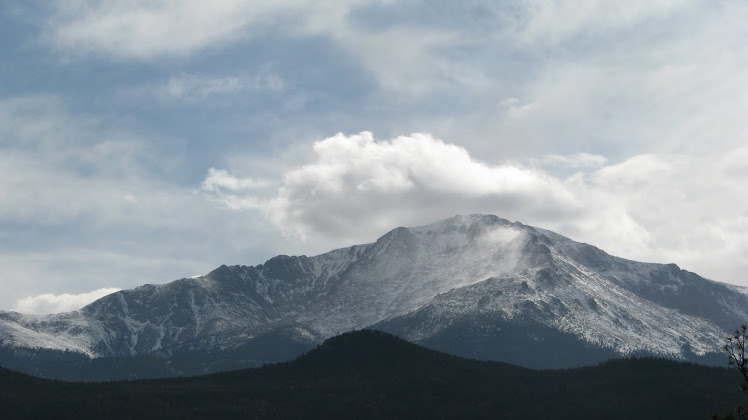
We tour Yellowstone from the south entrance and drove up the Grand Loop Road to Yellowstone Lake.  The lake is very large at 132 sq. miles and has a west thumb, south and southwest arm.  The water was a very deep blue.  These pictures were taken from Gulf Point.  It was a very bright day even though there were many clouds that formed over the lake.  The mountains in the distant is the Absaroka Range.

Saturday, July 4, 2015

Teton's Call of the Wild


It was an extraordinary visit to Jackson Hole Wyoming and The Grand Teton National Park.  I tried to give as much detail about my visit for those who are interested in visiting the park.  One thing I need to mention is the smell of sage is all over the meadows.  It is a wonderful scent and the wildflowers were endless.  The fresh cool air, mountain rivers and lakes, wildlife, the forest, the call of the wild is beckoning me to come back and I will again and again. 

Jackson Lake Lodge A Surreal Dining Experience


We had lunch at Jackson Lake Lodge and the view was surreal.  I have been at many restaurants where you get views of the ocean, beach, city lights, mountain rivers, etc. but we had a magnificent panoramic view!  There is nothing like it that I have ever experience.

Friday, July 3, 2015

Gros Ventre River


Kelly Loop starts at Antelope Flats Road, passes Mormon Row to the small town of Kelly.  The Gros Ventre Road follows the Gros Ventre River and the Bridger-Teton National Forest. We saw a lot of elk resting in the meadows and in the river.   

Two Ocean Lake and Pacific Creek River


It is always fun to take a side road adventure where most tourist usually will not travel.  We drove to Two Ocean Lake by turning onto Pacific Creek Road before we got to Moran Junction.  We were not sure exactly where the road would led but we wanted to see the Bridger-Teton National Forest.  The top photos are of Pacific Creek River and Ocean Lake and the photo right is the view at the intersection of Pacific Creek and Two Ocean Road. Pacific Creek Road is paved but very narrow and roughly follows the river and Two Ocean Road is an unpaved gravel road and is too narrow for two way traffic.  There are trailheads that follows the shoreline of the lakes and river.

Wednesday, July 1, 2015

Sawmill Pond Overlook at Moose-Wilson Road


Moose Wilson is a narrow and scenic little road that winds along the base of the mountains between Moose and Teton Village.  There is barely enough room for two way traffic and at several places it is only one lane.  It passes water falls, beaver ponds and marshy areas. The bottom photo is at Sawmill Pond Overlook which is known for sighting wildlife.

Cascade Canyon


Tuesday, June 30, 2015

Moulton Barn


In 1910 the land east of Blacktail Butte was homesteaded by Mormons. The Moulton Barn is a popular photographic subject for visitors as well as the meadows across from the barn.  The area became known as Mormon row and is located on Antelope Flats Road.

Approaching Storm Bridger-Teton National Forest


We drove down Antelope Flats Rd to Gros Ventre Road into the entrance of Bridger-Teton National Forest.  A Storm was approaching so plans to explore the area and drive to Shadow Mountain was postpone.

Monday, June 29, 2015

Mount Moran Turnout


On a cloudless morning with a perfect blue sky, Mount Moran Turnout offered another panoramic view.

Meandering Snake River


In 1942 photographer Ansel Adams took a picture of Snake River standing on a car to give him better elevation and scope.  His pictures are world famous and were taken in black and white.  The photo above is my picture in black and white of the same landscape except there are trees and bushes now blocking the view of the river's curve. How technology and photography has changed since his time.  I am an amateur photographer but the advancement of the digital SLR camera and a computer with editing software gives me as good results.

Schwabacher's Landing and Beaver Ponds


At Schwabacher's Landing there were spring creeks, beaver ponds, and a hiking trail around the different ponds.  I was surprised at the number of beaver dams that backed up the water. It is located down a marked dirt road north of Moose Junction.

Oxbow Bend Turnout


Signal Mountain and Mt. Moran dominate the background of Oxbow Bend with a rich array of pine, spruce and aspen trees.  There were many ducks in the water at the far end of the lake. The water surface was very calm and reflected the clouds and trees.  Another nature painting in many colors in process.

Geologic Drama Teton Glacier Turnout


This turnout is located between the Moose Visitor Center and Jenny Lake.  It offers a close view of the rugged canyon between the Grand Teton and Mount Owen.  A herd of elk came out into the nearby meadow.

Jackson Lake Shades of Blue


The lake has splashes of blue watercolor shades from the sky, mountain peaks to the mirror reflections in the water.  The depth of the different blue values is dramatic and aesthetic to behold and alluring. This is when photography frustrates me because no camera can possibly capture the stunning panoramic scene.

Sunday, June 28, 2015

Valley View at Signal Mountain Summit


More spectacular views of the valley from the Signal Mountain Summit.

Signal Mountain Summit


We drove up to the summit on a narrow road to unsurpassed panoramic views of the park.  The road continues to a dead-end parking area, and there is a short trail that leads up a flight of steps.  It is a spectacular spot for views across the valley and the Teton range. 

Jenny Lake Loop Grand Teton National Park


Jenny Lake Overlook Grand Teton National Park


In the east shore of Jenny Lake is a scenic turnout and view that is sixty feet above the lake.  There is also a hiking trail along side of the shoreline. 

Saturday, June 27, 2015

The Teton Range Highway 89


The Teton Range is 40 miles long, 7-9 miles wide. The Highest peak is the Grand Teton, elevation 13,770 feet. There are Eight peaks over 12,000 ft in elevation. Bison among the wildflowers on Highway 89.

Windy Point Turnout Grand Teton National Park


 Windy Point Turnout is the southern angle view of the Grand Teton.